


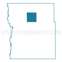
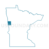
Flowing Twp. Voting District, Clay County, Minnesota
About
Outline

Summary
| Unique Area Identifier | 601528 |
| Name | Flowing Twp. Voting District |
| County | Clay County |
| State | Minnesota |
| Area (square miles) | 35.96 |
| Land Area (square miles) | 35.93 |
| Water Area (square miles) | 0.03 |
| % of Land Area | 99.92 |
| % of Water Area | 0.08 |
| Latitude of the Internal Point | 47.02714990 |
| Longtitude of the Internal Point | -96.51284910 |
Maps

Graphs
Select a template below for downloading or customizing gragh for Flowing Twp. Voting District, Clay County, Minnesota


Neighbors
Neighoring Voting District (by Name) Neighboring Voting District on the Map
- Felton Twp. Voting District, Clay County, MN
- Hagen Twp. Voting District, Clay County, MN
- Keene Twp. Voting District, Clay County, MN
- Moland Twp. Voting District, Clay County, MN
- Morken Twp. Voting District, Clay County, MN
- Spring Prairie Twp. Voting District, Clay County, MN
- Viding Twp. Voting District, Clay County, MN
Top 10 Neighboring County Subdivision (by Population) Neighboring County Subdivision on the Map
- Spring Prairie township, Clay County, MN (368)
- Moland township, Clay County, MN (299)
- Morken township, Clay County, MN (156)
- Keene township, Clay County, MN (155)
- Hagen township, Clay County, MN (154)
- Viding township, Clay County, MN (103)
- Felton township, Clay County, MN (86)
- Flowing township, Clay County, MN (77)
Top 10 Neighboring Unified School District (by Population) Neighboring Unified School District on the Map
- Dilworth-Glyndon-Felton School District, MN (6,082)
- Hawley Public School District, MN (4,077)
- Ulen-Hitterdal Public School District, MN (1,692)